Introduction to Florida’s Weather Patterns
Florida, known for its warm and inviting climate, experiences a unique set of weather patterns that distinguish it from other regions in the United States. The state predominantly features a tropical climate, with two main seasons: the wet season, which extends from May to October, and the dry season, from November to April. This dichotomy in weather conditions is influenced significantly by Florida’s extensive coastline, which spans both the Gulf of Mexico and the Atlantic Ocean.
During the wet season, Florida is characterized by high humidity, frequent thunderstorms, and heavy rainfall. These conditions are often attributed to the warm ocean waters that surround the state, which provide ample moisture and energy for storm development. In contrast, the dry season sees cooler temperatures and much lower humidity, making it the preferred time for outdoor activities and tourism. However, even during this period, occasional cold fronts can bring brief episodes of cooler weather.
Another critical aspect of Florida’s weather is its vulnerability to hurricanes and tropical storms. The state’s geographical location makes it a prime target for these powerful systems, particularly during the Atlantic hurricane season, which runs from June 1 to November 30. Hurricanes can have devastating impacts, bringing strong winds, heavy rains, and storm surges that can lead to significant property damage and loss of life. This inherent risk underscores the importance of diligent weather monitoring and preparedness.
Florida’s weather is a dynamic interplay of tropical influences and coastal effects, making it essential for residents and visitors alike to stay informed about current conditions and forecasts. Understanding these patterns is not only crucial for daily planning but also for long-term safety, especially during hurricane season. By recognizing the state’s climatic tendencies and the factors that drive its weather, individuals can better navigate the challenges and opportunities presented by Florida’s unique environment.
The Role of the National Hurricane Center (NHC)
The National Hurricane Center (NHC) plays a pivotal role in safeguarding lives and property through its precise hurricane forecasting and tracking capabilities. Established in 1965, the NHC is a division of the National Weather Service and operates under the National Oceanic and Atmospheric Administration (NOAA). The center’s primary mission is to monitor tropical cyclones in the Atlantic and Eastern Pacific basins, providing accurate and timely warnings to mitigate the impacts of these potentially devastating storms.
The NHC employs a wide array of data sources to achieve its mission, including satellite imagery, reconnaissance aircraft, weather buoys, and radar systems. Satellite imagery provides real-time visuals of storm development and movement, while reconnaissance aircraft, often referred to as “hurricane hunters,” gather critical data from within the storm itself. Weather buoys contribute valuable information on sea surface temperatures and atmospheric conditions, and radar systems offer detailed insights into precipitation patterns and storm intensity.
Dissemination of information is another crucial function of the NHC. The center issues regular advisories, warnings, and updates to keep the public and emergency management agencies informed. These updates are disseminated through various channels, including the NHC’s website, social media platforms, and partnerships with media organizations. During hurricane season, which spans from June 1 to November 30, the frequency and urgency of these updates increase, reflecting the heightened risk and the need for continuous monitoring.
The importance of the NHC’s updates cannot be overstated. Timely and accurate information enables individuals, communities, and government agencies to make informed decisions about evacuations, resource allocation, and emergency response measures. The NHC’s efforts not only save lives but also help to minimize property damage and economic losses. Their comprehensive approach to hurricane tracking and forecasting ensures that all stakeholders are well-prepared to face the challenges posed by these formidable natural events.
Key Weather Resources: Bay News 9, Mike’s Weather Page, and More
For residents and weather enthusiasts in Florida, staying informed about weather patterns and hurricane tracking is paramount. Several reputable resources offer comprehensive updates, forecasts, and educational content, making them indispensable tools for navigating Florida’s unique climate. Among these, Bay News 9, Mike’s Weather Page, and Space City Weather stand out for their reliability and depth of information.
Bay News 9 serves as a primary weather resource for many Floridians. This local news station provides real-time weather updates, accurate forecasts, and detailed hurricane tracking. Their team of meteorologists employs advanced technology to deliver precise weather data, helping residents prepare for severe weather events. Bay News 9’s dedication to community-focused reporting ensures that critical information is accessible and understandable, fostering a well-informed public.
Mike’s Weather Page, another essential resource, offers a unique blend of professional meteorology and accessible content. Founded by Mike Boylan, this platform aggregates weather data from various sources, including the National Hurricane Center and global weather models. Its user-friendly approach makes complex meteorological information comprehensible for the average person. Mike’s Weather Page is particularly valuable during hurricane season, providing timely updates and critical insights into storm developments.
Space City Weather, although based in Houston, Texas, has gained popularity among Floridians for its clear and concise weather reporting. This platform excels in providing detailed forecasts and explanations of weather phenomena, making it an excellent educational resource. The site’s commitment to “no hype” weather reporting ensures that users receive accurate information without sensationalism, which is especially important during hurricane threats.
These platforms collectively enhance our understanding of Florida’s weather, offering tools and knowledge to stay prepared. By utilizing such resources, individuals can better navigate the challenges posed by the state’s dynamic climate, ensuring safety and informed decision-making.
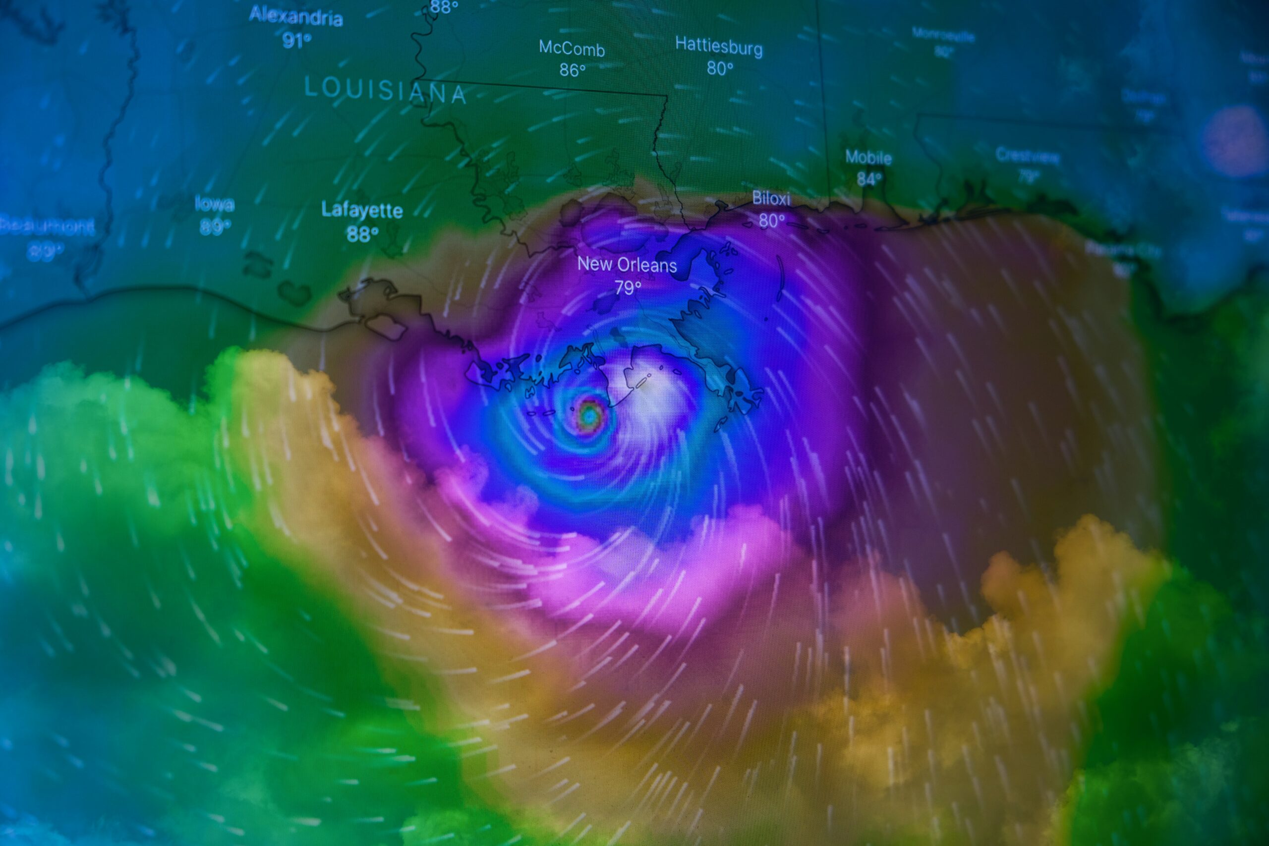
Understanding Hurricane Tracking and Spaghetti Models
Hurricane tracking is a critical aspect of meteorology, especially in regions like Florida that are frequently affected by these powerful storms. One of the primary tools used in this process is the “spaghetti model,” a visualization that helps forecasters predict hurricane paths. Spaghetti models, named for their resemblance to a plate of tangled spaghetti, consist of multiple lines representing different forecast models. Each line, or “spaghetti strand,” indicates a potential path that the hurricane could take based on various atmospheric conditions and computational predictions.
Interpreting spaghetti models requires an understanding of their inherent strengths and limitations. These models are particularly valuable because they compile data from various sources, including global weather models, regional models, and ensemble forecasts. By considering multiple scenarios, forecasters can gain a more comprehensive view of potential hurricane trajectories. The consensus among these different paths can provide a clearer indication of the most likely route a hurricane will follow, which is crucial for issuing warnings and preparing for potential impacts.
However, spaghetti models also come with limitations. The divergence of the lines can often be substantial, especially several days out from the storm’s current position. This spread indicates uncertainty and reflects how small variations in initial conditions can lead to significant differences in the storm’s path. Consequently, while spaghetti models are invaluable for long-range forecasting and trend analysis, they should not be solely relied upon for pinpoint accuracy. Instead, they should be considered alongside other meteorological data and expert analyses.
The contribution of spaghetti models to understanding potential hurricane paths and impacts is undeniable. They allow for a nuanced view that incorporates a range of possibilities, aiding in the formulation of more informed and effective response strategies. By interpreting these models correctly, meteorologists, emergency planners, and the public can better anticipate and respond to the threats posed by hurricanes, ultimately enhancing community safety and resilience.
The Impact of Tropical Storms and Hurricanes on Florida
Tropical storms and hurricanes have a profound impact on Florida, a state frequently in the path of these powerful weather events. The consequences of these storms are multifaceted, often resulting in widespread flooding, extensive wind damage, and formidable storm surges. Understanding these impacts is crucial for residents and officials alike to enhance preparedness and response strategies.
Flooding is one of the most immediate and dangerous effects of tropical storms and hurricanes in Florida. Heavy rainfall can overwhelm drainage systems, leading to significant inland flooding. Coastal areas are particularly vulnerable as storm surges can push seawater onto the land, compounding the flooding problem. For example, Hurricane Irma in 2017 caused severe flooding across the state, with some areas experiencing more than 10 inches of rain.
Wind damage is another critical concern. Hurricanes bring sustained high winds and powerful gusts that can cause catastrophic damage to buildings, infrastructure, and vegetation. Historical accounts highlight the devastation caused by these winds; Hurricane Andrew in 1992, for instance, brought winds exceeding 165 mph, resulting in billions of dollars in damage and leaving thousands homeless.
Storm surges present a unique threat to coastal communities. These surges are essentially a rise in seawater level caused by the storm’s winds pushing water towards the shore. The impact can be devastating, inundating homes, eroding shorelines, and destroying ecosystems. The storm surge from Hurricane Michael in 2018 reached up to 14 feet in some areas, causing severe damage along the Florida Panhandle.
Given these significant impacts, the importance of preparedness and response strategies cannot be overstated. Floridians are encouraged to develop hurricane plans, stay informed about weather updates, and adhere to evacuation orders when necessary. Historical examples underscore the necessity of robust infrastructure and effective emergency response systems to mitigate the damage caused by these powerful storms.
By understanding the specific impacts of tropical storms and hurricanes on Florida, residents and authorities can better prepare for and respond to these natural events, ultimately reducing their destructive potential.
Gulf of Mexico: A Hotspot for Tropical Activity
The Gulf of Mexico plays a pivotal role in the development of tropical storms and hurricanes, making it a critical area of focus for meteorologists and residents alike. Several environmental conditions contribute to this region being a hotspot for tropical activity. Warm sea surface temperatures are a primary factor, providing the necessary heat and moisture to fuel storm systems. Typically, sea surface temperatures in the Gulf exceed 80°F (27°C) during the hurricane season, which runs from June to November. This thermal energy is a key ingredient in transforming a tropical disturbance into a powerful hurricane.
Another significant factor is the presence of high humidity levels in the mid to lower atmosphere. This abundance of moisture supports the convection processes that drive storm formation. Combined with the warm sea surface temperatures, these humid conditions create an ideal environment for the genesis and intensification of tropical cyclones. Additionally, the Gulf of Mexico often experiences low vertical wind shear during hurricane season. Vertical wind shear refers to the change in wind speed and direction with height. Low wind shear allows storm systems to organize and strengthen without being torn apart by varying wind patterns.
The geography of the Gulf also plays a crucial role. Surrounded by landmasses such as Florida, Texas, and the Yucatan Peninsula, the Gulf acts as a natural basin that can trap and concentrate heat and moisture, further enhancing storm development. As these storms form and intensify, they pose significant threats to the surrounding regions. For instance, Florida and Texas often find themselves in the paths of these powerful systems, facing risks of severe flooding, wind damage, and storm surges.
Understanding the unique environmental conditions of the Gulf of Mexico is essential for effective hurricane tracking and preparedness. By closely monitoring sea surface temperatures, humidity levels, and wind patterns, meteorologists can better predict the formation and trajectory of tropical storms, ultimately helping to mitigate their impact on vulnerable coastal areas.
Tracking Tropical Storms: Tools and Techniques
Tracking tropical storms is an intricate process that leverages advanced technology and sophisticated methodologies. Meteorologists rely on a combination of tools to monitor and predict storm behavior, ensuring accurate and timely information dissemination. One of the primary tools used in tracking tropical storms is satellite imagery. Satellites orbiting the Earth capture real-time images of weather systems, providing invaluable data on the formation, movement, and structure of tropical storms. These images help meteorologists observe cloud patterns, sea surface temperatures, and atmospheric conditions, which are crucial for predicting storm development and potential intensification.
Another essential tool in storm tracking is radar. Ground-based radar systems emit radio waves that bounce off precipitation particles within a storm, allowing meteorologists to visualize the storm’s internal structure. This data is vital for identifying areas of heavy rainfall, wind intensity, and potential tornado formation within the storm system. Doppler radar, in particular, offers enhanced capabilities by measuring the velocity of precipitation particles, providing insights into wind speed and direction.
Reconnaissance aircraft, often referred to as “hurricane hunters,” play a critical role in tropical storm tracking. These aircraft are specially equipped to fly directly into the storm, gathering detailed measurements of atmospheric pressure, temperature, humidity, and wind speed. The data collected is transmitted in real-time to meteorologists, offering a unique perspective on the storm’s intensity and structure. This information is indispensable for refining predictions and issuing timely warnings.
Finally, computer models are integral to the process of predicting tropical storm paths and intensities. These models use mathematical algorithms to simulate the behavior of storm systems based on current and historical data. By inputting real-time data from satellites, radar, and reconnaissance aircraft, meteorologists can generate forecasts that predict the storm’s trajectory, potential landfall locations, and intensity changes. Various models, such as the Global Forecast System (GFS) and the European Centre for Medium-Range Weather Forecasts (ECMWF), are compared and analyzed to produce the most accurate predictions possible.
Through the combined use of satellite imagery, radar, reconnaissance aircraft, and computer models, meteorologists can effectively track tropical storms and provide critical information to the public. These tools and techniques are essential for minimizing the impact of tropical storms, enabling communities to prepare and respond appropriately to these natural phenomena.
Preparing for and Responding to Tropical Storms and Hurricanes
Preparation and informed responses are essential when dealing with tropical storms and hurricanes. By taking proactive measures, individuals and communities can significantly mitigate the effects of these powerful natural events. One of the first steps in preparation is creating a comprehensive emergency plan. This plan should detail evacuation routes, designate a meeting place for family members, and account for the needs of pets and vulnerable individuals. It’s crucial to ensure that all family members are familiar with the plan and understand their roles and responsibilities.
An integral component of hurricane preparedness is assembling a disaster supply kit. This kit should include essentials such as non-perishable food, water, medications, important documents, and first aid supplies. Additionally, it is advisable to have items like flashlights, batteries, and a battery-powered or hand-crank radio to stay updated on weather alerts. Ideally, the kit should be able to sustain each member of the household for at least 72 hours. Regularly checking and updating the contents of the kit can ensure readiness at all times.
Staying informed through reliable weather updates is another critical aspect of hurricane preparedness. Trusted sources, such as the National Hurricane Center (NHC) and local meteorological agencies, provide timely and accurate information. Utilizing weather apps, subscribing to emergency alert systems, and monitoring local news can help individuals stay ahead of developing situations. Understanding the different types of alerts, such as watches and warnings, can guide appropriate actions and responses.
Communities can enhance their resilience by participating in local preparedness programs and initiatives. Engaging with community emergency response teams (CERT) and attending preparedness workshops can foster a culture of readiness and cooperation. By taking these steps, individuals and communities can not only safeguard their lives and property but also contribute to a more resilient society in the face of tropical storms and hurricanes.